
Loures Riverfront
TOPIARIS Landscape Architecture
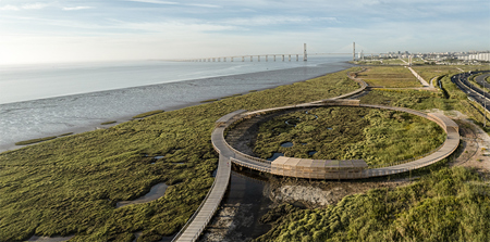
The initial premise was to complete the intermunicipal pedestrian and cycling continuity, connecting Lisbon to Vila Franca de Xira, and consolidate an important strategic plan that aims to implement a continuous route along the Tagus Riverfront in the Lisbon Metropolitan Area. At the same time, it was intended to encourage the connection to the Loures urban areas, isolated by roads and railway infrastructures. As a result, this route constitutes an important mobility infrastructure with a significant impact on the current daily commuter matrix, contributing to the reduction of CO2 emissions and positively affecting the lives of the surrounding communities. An analysis of the project area and its surroundings revealed a surprising landscape: a mosaic of natural ecosystems in the vicinity of a highly urbanized zone. Unexpectedly, just minutes away from densely populated neighbourhoods, one can find mudflats, salt marshes, native reed beds, all supporting a diverse array of flora and fauna habitats. Taking inspiration from the meandering drainage lines, the trail avoids straight lines in favour of a gentle, curving path, that allows observation of the habitats from different perspectives. Instead of providing a quick journey from point A to B, the project was designed to encourage a slower experience of the environment. At km 2 from south, a special feature diverts from the path: The Tagus Circle. It forms a perfect loop and was created to enable the observation of the salt marsh in its different stages, showcasing its high ecological value, and highlighting its resilience and vulnerability. As we walk around its perimeter, we observe the sequence of distinct sub environments, each playing a vital role in the marsh's ecosystem. To preserve the marshes, the entire path consists of a raised wooden boardwalk, accommodating both pedestrian and bicycle traffic. Its variable elevation allows for the free flow of water, protecting this structure from flooding, while offering diverse experiences. Along the riverside trail, several new features have been added to enhance the journey. Observation and rest areas, slightly suspended off the main path, invite visitors to stop. Equipped with benches, bird observation counters, and a protective wooden structure that provides shade, these areas are the perfect place to stay and enjoy the place. Interspersed between are shading tunnels, offering a cooler space for pedestrians and cyclists to slow down. Restored from the site's industrial past, two concrete piers are now linked with the boardwalk, allowing access to the river, and welcoming local fishermen. This park would not only serve as a circulation and recreational route, but also as a platform for research, nature interpretation, and public education, raising public awareness for the importance of estuarine ecosystems, biodiversity conservation, and ocean management.